Laura Ebanista1, Stefania Nisio2 & Sergio Madonna3
1 Sapienza University of Rome, Piazzale Aldo Moro 5, 00185 Roma.
2 ISPRA – Dip. Servizio Geologico d’Italia, Via V. Brancati 48, 00144 Roma.
3 University of Tuscia, Via S. Camillo de Lellis snc, 01100 Viterbo.
SM, 0000-0001-8862-0463; LE 0000-0002-2650-7657; SN 0000-0002-5422-3694.
Article
Corresponding author e-mail: sermad@unitus.it
Citation:Ebanista L., Nisio S. & Madonna S. (2023) – Analysis of natural risks in the southern Pontine plain, the role of the historical-archaeological sources: the case of Ninfa (Italy, LT). Rend. Online Soc. Geol.It., 61, 37-42, https://doi.org/10.3301/ROL.2023.44.
GuestEditor:Simone Sterlacchini
Submitted:10 March 2023
Accepted:13 July 2023
Publishedonline:18 October 2023
Copyright:© Società Geologica Italiana, 2023
INTRODUCTION
Numerous centres characterize the Pontine plain’s southern district (Latium Region, Italy), with great cultural and landscape value, often threatened by geological hazards (Fig. 1). The comparative analysis of archaeological data and historical cartography is fundamental for defining the phenomena that affected the territory and how these influenced settlement dynamics.
The Ninfa case study is emblematic of the importance of multidisciplinary approaches, including historical information, in studying natural hazards putting at-risk cultural heritage. Ninfa is located close to the southwestern slopes of the Lepini mountains
(Fig. 1) and covers a flat surface slightly sloping towards the south, with average altitudes close to 26 meters above sea level (Fig. 2). This site of great historical-archaeological, architectural, naturalistic, geological and hydrogeological values appears today in its last transformation: the suggestive English-style garden realized in 1921 by Gelasio Caetani among the medieval ruins of the medieval village.
The ‘garden city’ is limited to the west-southwest by the natural park of Pantanello and to the north by Ninfa’s lake, defined by an artificial barrier, from which originates the homonymous river (also called Ninfeo). The available geomorphological geological and geophysical data converge to hypothesize that Ninfa’s lake subcircular shape originated from a sinkhole, a typology of phenomena that is very diffused in the Pontina plain area due to its stratigraphic and structural characteristics (Fig. 1B).
MATERIALS AND METHODS
To better understand the sinkholephenomena and consider the fundamental contribution of historical cartography, a great number of historical maps available for the Pontina Plain area have been acquired. Frutaz’s famous volume “Le Carte del Lazio” (Frutaz, 1972) collects an extraordinary amount of well-indexed material, making the research approach well-structured and systematic. However, acquiring the maps and their digitization and georeferencing can be difficult. In fact, a large part of the cartography produced, especially between the seventeenth and eighteenth centuries, is characterized by a perspective vision and
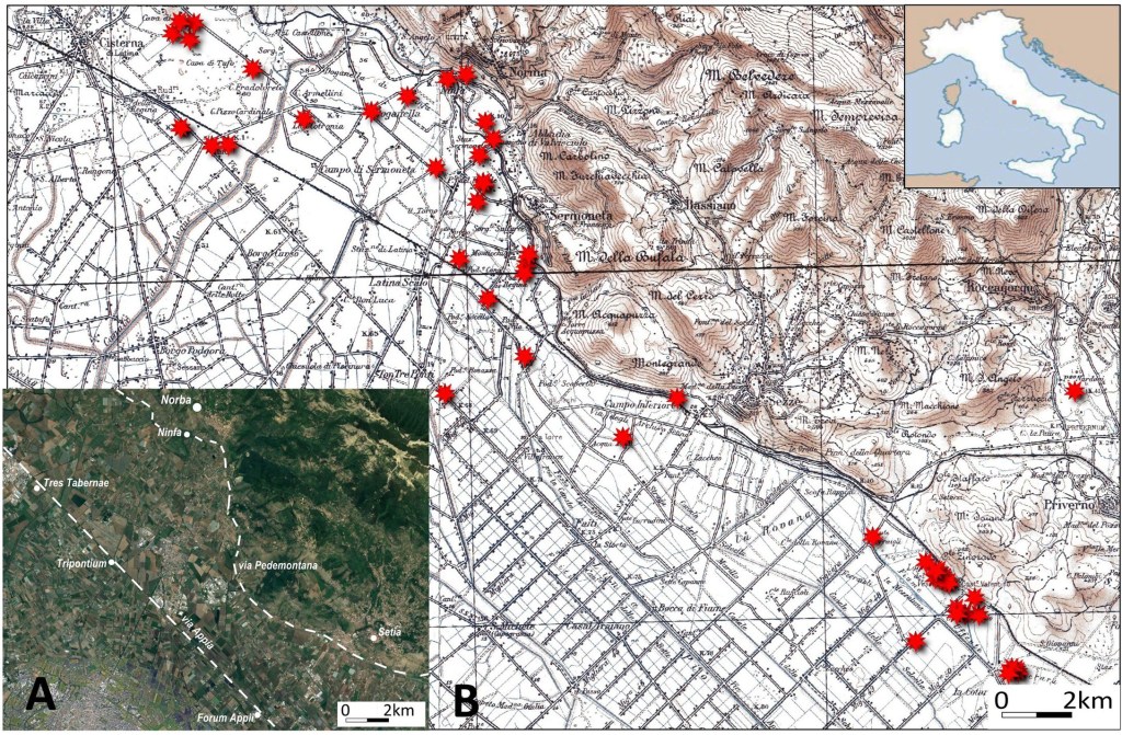
Fig.1–A)SinkholephenomenarecordedintheNympharea(redstars)ona1:100,000scaleIGMtopographicalmap;B)Locationofsettlementsandroadway layout during antiquity (base: GoogleEarth, rendering by Laura Ebanista).
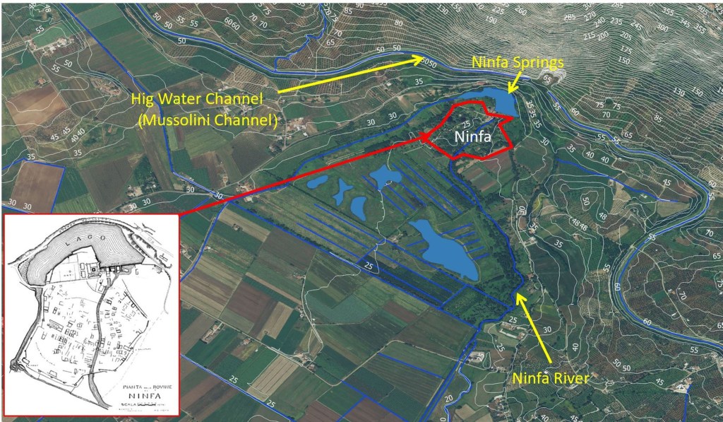
Fig.2–MorphologicalandhydrographiccharacteristicsoftheNinfaarea(LazioRegion,elementsoftheTopographicGeoDataBaseDGBT2009ona satellitemap).
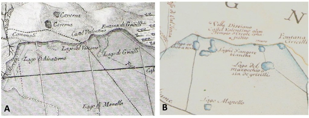
Fig. 3 – Example of using historical maps for the location of sinkhole: the Manello Lake, A) excerpt of a map of 1777 by Ing. Gaetano Rappini “ Sopra ildisecamento delle Paludi Pontine; B) excerpt of a map of 1802 (anonymous author).In both these maps, the lake, interpreted as a sinkhole buried with the reclamations, was present.
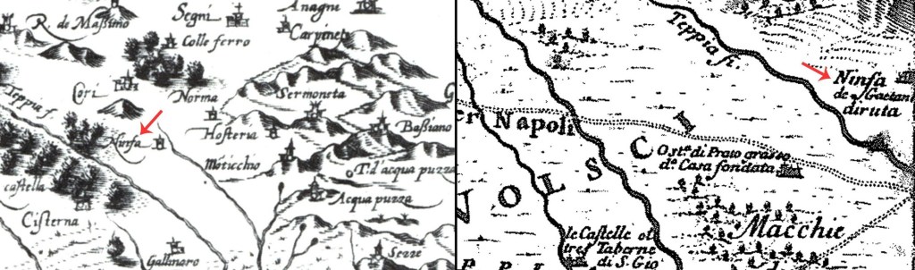
Fig.4.Historicalmaps:ontheleftA.Magini1604(Frutaz,1972,tav.54),ontherightG.F.Ameti1693(Frutaz,1972,tavv.176-177).
Almagià R. (1922) – Paludi Pontine. Le vie d’Italia (Touring Club Italiano) anno 1922 (marzo), 241-250.
Almagià R. (1934) – Le trasformazioni del paesaggio geografico nella regione pontina. Comptes rendus du Congrès international de géographie, Varsovie, tome 4. Varsovie: Depot general Kasai m. Mianowskiego, 178-188.
Bono (1995) – The sinkhole of Doganella (Pontina, Plain,Central Italy).
Environ. Geol., 26, 48-52.
Caciorgna M.T. (1996) – Marittima medievale. Territori società, poteri, Il Calamo, Roma.
Cancellieri M. & De Rossi G.M. (1990) – L’organizzazione antica del territorio di Ninfa. In Fiorani L. (ed) – Ninfa, una città un giardino. Atti del Colloquio della Fondazione Camillo Caetani Roma, Sermoneta, Ninfa 7-9 ottobre 1988, L’Erma di Bretschneider, Roma, 39-66
Cancellieri M. 1990 (1990) – Il territorio pontino e la via Appia. Quaderni del Centro di studio per l’archeologia etrusco italica, 18, 61-71.
Caramanna G., Ciotoli G., Nisio S. (2008) – A review of natural sinkhole phenomena in Italian plain areas. J. Nat. Haz., 45, 145- 172, https:// doi.org/10.1007/s11069-007-9165-7.
Caramanna G., Ciotoli G., Nisio S., Vita L. (2006) I fenomeni di sinkholes in Italia: inventario dei fenomeni naturali ed alcuni casi di studio. Mem. Descr. Carta Geol. It, 71, 123-124.
Ciotoli G., Finoia m.G., Liperi L., Meloni F., Nisio S., Tonelli V., Zizzari
P. (2015) – Sinkhole susceptibility map of the Lazio Region, central Italy. J. Maps, 12-2, 287-294.
De Francesco D. (2004) – La proprietà fondiaria nel Lazio secoli IV-VIII storia e topografia, Quasar, Roma 2004.
Ebanista L. (2020) – Interventi di regimentazione idrica sul litorale pontino nel corso dei secoli. In Busana M.S., Novello E., Vacilotto
A. (eds) – Archeologi nelle terre di bonifica. Paesaggi stratificati e antichi sistemi da riscoprire e valorizzare, Cleup, Padova, 63-81.
Frutaz A. P. (1972) – Le carte del Lazio, Roma 1972.
Harley J.B. (1968) – The Evaluation of Early Maps: Towards a Methodology.
Imago Mundi, 22, 62-74.
Harley J.B. (1988) – Maps, Knowledge and Power. In Cosgrove D. e Daniels S. (eds), The Iconography of Landscape. Essays on the Symbolic Representation, Design and Use of past Environments, Cambridge University Press, Cambridge, 277-312.
Harley J.B. (1989) – Deconstructing the map. Cartographica, 26, 1-20.
Harley J.B. (2001) – The new nature of maps: essays in the history of cartography, J. Hopkins University press, London.
Knowles A. K. (2002) – Past Time, Past Place: Gis for History, ESRI Inc., Redlands, CA.
Madonna S., Nisio S. & Fenelli M. (2020) – Il Lacus Turni ed il Lacus Juturnae due laghi scomparsi della provincia di Roma Mem. Descr. Carta Geol. It., 107, 113-138.
Meloni F., Nisio S., Liperi L., Tonelli V., Zizzari P. Ciotoli g. (2013) -Carta dei sinkholes della Regione Lazio. Mem. Descr. Carta Geol. It., 93.
Nisio S. (2003) – I fenomeni di sprofondamento: stato delle conoscenze ed alcuni esempi in Italia Centrale. Il Quaternario, 16 (1), 121-132.
Nisio S. (2008) – I sinkholes nel Lazio. Mem. Descr. Carta Geol. It., 85, 33-148.
Nisio S. (2014) – I sinkholes tra storia, mito e leggenda. Mem. Descr.
Carta Geol. It., 96, 271-296
Nisio S. (2014) – Le ricerche storiche nello studio dei fenomeni di sprofondamento. Mem. Descr. Carta Geol. It., 96, 261-270
Nisio S., Caramanna G., Ciotoli G. (2005) – Sinkholes hazard in Italy: first results on the inventory and analysis of some case studies. In: Parise & Gunn (eds) Natural and Anthropogenic Hazards in Karst areas: Recognition, Analysis and Mitigation. Geol. Soc., London, Spec. Publ., 279, 23-45.
Spiccia L. (2004) – Ninfa una storia millenaria, Littera Antiqua, Sermoneta.
Tomassetti G. (1979) – La campagna romana antica, medioevale e moderna, E. Loescher & C., Roma.
Turchetti R. (1994) – Ninfa. In Il Lazio di Thomas Ashby 1891-1930, Fratelli Palombi Editori, Roma, 161-162.

Lascia un commento